How To Use This Map

This mapping initiative used publicly available data to identify potential environmental hazards located within a one-mile radius of a public school building in the southwestern Pennsylvania region. This ten-county region includes: over 336,000 children attending public schools, 674 public school buildings, 128 school districts, and 7,040 square miles.

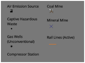
This initiative mapped the following potential environmental hazards: air emission sources, gas wells (unconventional also known as Marcellus wells, as well as compressor stations), mining operations, and active rail lines. This first phase reviewed public schools, charter schools and technical schools. Data was collected from the PA Department of Environmental Protection (gas wells, mining hazards); the PAMAP program (rail lines); and the Environmental Protection Agency (air emission sources).

To pan across the map, right click and hold the button on your mouse while moving the cursor across the screen.

Each school building is identified as a point (circle on the map). The darker the circle, the more environmental hazards located within that one-mile radius of the school. For example, a red dot has a higher number of potential hazards, a yellow dot has fewer. Each school has a large circle drawn around it, which depicts the one-mile area. If you only see a symbol (depicting an environmental hazard) and not a circle (identifying the school and one-mile radius), you will have to zoom out (- button) to locate the school.

The school districts are also outlined on this map. When you click on the district, its boundary will be highlighted in turquoise blue. The more overlaps of environmental hazards within that school district, the darker the shade of purple. The location of environmental hazards can impact more than one school in a district.

In the upper left corner of the map are + and – buttons. Use this feature to zoom in and out of a particular area on the map to find your school or district. You may also search for your school by clicking here. The symbols depicting environmental hazards on the map are depicted as follows:

Map Key

Introduction

Children in the United States spend an average of 1,074 hours at school per year, which equates to nearly 14,000 hours during their years in the K-12 school system. There are over 336,000 children who attend a public, charter, or technical school in southwestern PA. Because children and teens spend so much of their time in schools and on school grounds, it is important for these spaces to be healthy and safe environments for children to learn, play, and grow.

While developing, children and teens are especially vulnerable to environmental pollution. Children’s bodies are different than adults, their organs and systems are still developing. Pound for pound, children breathe more air, consume more food and drink more water than adults. There are especially important and vulnerable times during a child’s development when we need to think of potential exposures to environmental hazards, and the cumulative effects those exposures can have on a child’s growth and well-being. The timing of exposure, size of the person, amount of exposure and cumulative effects from exposures are all influencing factors on a child’s health.

Because outdoor contaminants have the ability to impact indoor spaces, many of these environmental hazards have the potential to impact children’s health, as well as the health of anyone in the school setting. Many of these sources release known or probable carcinogens, pollutants that are linked with increased risk of lung or heart disease, and chemicals that can trigger allergy and asthma symptoms.

Therefore, it is important to characterize potential environmental hazards nearby schools where children spend a majority of the day and year. Characterizing potential hazards begins by first identifying what and where potential environmental hazards persist in the environment. Once identified, environmental hazards can then be further characterized by determining how much, how often, and how long exposures exist to a population of interest.

Air Emission Sources

Data were collected from the National Emissions Inventory (NEI) database, which includes air emissions sources of both criteria and hazardous air pollutants. The NEI Point data category contains “emissions estimates for sources that are individually inventoried and usually located at a fixed, stationary location, although portable sources such as some asphalt or rock crushing operations are also included. Point sources include large industrial facilities and electric power plants, but also increasingly include many smaller industrial and commercial facilities, such as dry cleaners and gas stations, which had traditionally been included in Nonpoint sources.”

School Air Emission Source

A summary of the NEI sources mapped in southwestern PA is below:

  • Nearly half of all schools mapped have one or more air emission source within a one-mile radius.
  • 61% of school districts have one or more air emission source within a one-mile radius of school building.
  • One school district has 201 air emission sources located within the one-mile radius of a school in their district.
Gas Wells (Unconventional) & Compressor Stations

There are many public health exposure periods throughout the gas well development process. From site preparation, to installation, to well completion, air pollutants and chemicals can have impacts on public health.

Playground with Gas Drilling

Our analysis of active unconventional (Marcellus) gas wells in southwestern PA concluded the following:

  • There are 350 unconventional wells in the southwestern PA region situated within one-mile radius of a school building./li>
  • There are 75 schools that have one or more unconventional wells within a one-mile radius of the school building.
  • There are 30 school districts that have one or more wells situated within a one-mile radius of one or more of their school buildings.
  • Two school districts have 16 gas wells within a one-mile radius of a school building.
  • There are 41 compressor stations within a one-mile radius of a school building. Three schools have three (3) compressor stations within a one-mile radius of the building.
Mining Operations

Coal mines, active or not, release a variety of harmful toxins into the air that people breathe in by proximity. Coal mine pollutants include coal ash, sulfur dioxide, mercury, and 67 other airborne toxins. Some toxins may start to negatively affect health almost immediately after exposure, and even after longer term exposure to even minuscule amounts.

mining at a elementary school

Pennsylvania is one of the top ten states that produces aggregate/crushed stone, mostly consisting of surface operations. These surface mines produce high levels of dust and noise. Areas around these surface mines experience increased truck traffic, which raises the levels of diesel particulate matter in the air. Fine particulate matter, both diesel and dust, can stay suspended in, and travel over, large distances in the air.

Below is a summary of mining operations near public school buildings in southwestern PA.

  • here are 58 active mines in the southwestern PA region./li>
  • 41 public schools have one or more active mines within a one-mile radius of the school building.
  • 22 school districts have active mines within a one-mile radius of a school building.
  • One school district contains seven active mines within the one-mile radius of a school building in its district.
Rail Line (Active)

Approximately 49% of schools across southwestern PA are within one-mile of an active railroad. This equates to nearly 165,000 students potentially at risk. Railroad lines and hubs are hazards that experience heavy truck traffic and emit fine particulate matter, which is a public health hazard. Increased truck traffic (as well as increased traffic congestion in general) raises the local levels of diesel particulate matter. Developing children and teens are especially sensitive to the health hazards of increased particulate matter. Railroad lines can also be a source of heavy noise pollution, which can negatively affect concentration in classrooms.

Playground Near Train

Beyond the consequences of increased railroad traffic in general, the cargo that a train transports can pose another set of environmental hazards. As the national production of oil and gas rises, so does the number of train cars being used to transport crude oil. Transporting crude oil presents environmental hazards no matter the type of transport (whether its pipeline, ship, or train), but it is rail cars that come the closest to our town infrastructures. In the past half-decade there have been numerous crude oil rail car accidents. Rail cars carrying crude oil can cause uncontrolled spills, derailments, or even explosions impacting the health of an entire community.

Below is a summary of rail line in southwestern PA.

  • There are 316 schools that are within a one-mile radius of an active rail line.
  • There are 81 school districts that have an active rail line within a one-mile radius of a school in that district.
What You Can Do to Improve School Community Health

The presence of environmental hazards near schools is likely not something that we can change. But along with limiting future development of these facilities near schools, we can take steps to change how these facilities coexist with local communities.

Below are steps communities and school districts can take to protect public health:

  1. It’s unlikely that any school has a completely sealed building envelope. Moreover, its ventilation system is not designed to prevent harmful exposures to fine particles and toxic gases. At the very least, though, school facility managers should review their mechanical systems to ensure proper operation and make upgrades if warranted. Speak with your school’s facility director to make certain mechanical systems are working properly, inspected and maintained throughout the year. For example, ensure outdoor air intakes are clear and filters are replaced per the required maintenance schedule.
  2. Be aware of Air Quality Action Days and schedule outdoor recess accordingly, especially if you are in the vicinity of a potential environmental pollutant source. Also be aware that potentially harmful exposures may occur locally.
  3. Review and practice the district’s evacuation procedures to make certain sheltering and safe evacuation routes are in place.
  4. Share this information with local emergency responders to make certain a plan is in place in the event of an environmental emergency (explosion, train derailment, etc).
  5. Use this information as a planning tool for any new proposed industrial or manufacturing activity near a school setting and stay involved in community planning and decision-making that could potentially impact your school.
  6. Utilize this mapping tool for proper siting of new schools. School districts should solicit public input on proposed school hazards through the use of public notices, public meetings or hearings.
  7. Keep apprised of the industrial and manufacturing activities in your community. Be certain they are in compliance with the law and comment on any proposed permits that may impact the health of your school community.
  8. Ask your government leaders for a full accounting of all chemical hazards that are components of tar sands oil being transported.
  9. Support government initiatives that will bring additional funds to school districts for proper testing, updating and maintaining of their mechanical systems.
  10. Municipalities now have the opportunity to pass zoning ordinances to guide where gas drilling occurs in their communities, and prohibit other areas from drilling. Ask local officials to pass ordinances that require a one-mile buffer around any school or playground, thereby prohibiting any type of gas well development within that buffer zone.
  11. In Allegheny County, call the Allegheny Health Department (ACHD) at 412-687-2243 to report any unusual activities, odors or environmental emergency. Outside Allegheny County, report this information to the PA Department of Environmental Protection at 412-442-4000.

Contact Us to learn more about the facilities that may be releasing pollutants in your community or to request a staff member to speak at your school.